
Night 3 of Chanukah
The Definitive Location
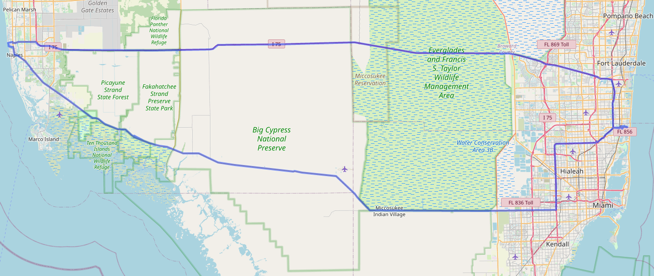
Taking some time off that needed to be used before the end of the year, and today, took a trip on the Tamiami Trail. This is part of my continued effort to get out, but yet avoid close contact with groups of people.
The Tamiami trail runs from Tampa to Miami, thus the name. We drove from Miami to Naples, Florida. The Trail opened in 1928, but since 1968 when Alligator Alley(now I-75 from Naples to Miami) opened, it has been more sparsely used.
Along the early part of the route is the Dade-Collier Training Airport, whcih was meant to be a large Miami airport, but was halted after only one runway was built. The airport’s callsign is amusingly TNT. 2.6 million sticks of dynamite were used to build the Tamiami trail.
The Trail forms the northern border of Everglades National Park, which is the third-largest park in the United States. The trail is the dividing line between the Everglades National Park and the Big Cypress National Preserve. The Preserve is a cypress swamp, compared to the Everglades which is a submerged prairie.
Our first stop was the Oasis Visitor Center, which is a former airport hanger/restaurant, which adjourns the Oasis Ranger Station airport. While we didn’t go inside, we were able to, shown by a dedicated park ranger, see some alligators.
We also made a brief photo stop at the Ochopee Post Office, which was a former storage shed that serves a region of 130 miles.
From there, we headed to the Big Cypress Bend Boardwalk. This takes you into yet another park, the Fakahatchee Strand State Park. We walked a bit of the boardwalk, which goes about a half mile into the park. If you weren’t looking for it, you wouldn’t find the boardwalk. We parked at a closed building, and walked a dirt trail off the highway until we found the boardwalk, which continued for another half mile.
After that, the road passed through the Picayune Strand State Forest, and the Ten Thousand Islands National Wildlife Refuge. The Ten Thousand Islands are a chain of hundreds(not thousands) of islands that are mostly uninhabited.
The road also passes along the Miccosukee reservation and multiple villages.
Our final destination was Naples, Florida. there, we got a look at the Gulf Of Mexico at Lowdermilk Park, one of the many beach parks in the area, before turning back and returning on Alligator Alley, aka I-75, which is the faster, if less scenic route.

I built this feature for myself. Using my own weather data when possible has been a desire of mine. Now, my website is set to compare my location to that of the custom stations I’ve designated, in this case two under my control. If I am close, it will use that data. If not, it will go to the fallback provider. The same fallback can be set for regional providers, like the US National Weather service and the Met Office, in case you wander into untracked territory.
The functionality also works for the weather in my sidebar, where you’ll see additional parameters such as the readings from my particulate sensors and any sensors I add in the future.
I did try to implement trip support in this version, but due to issues, I have pushed that off to rethink.